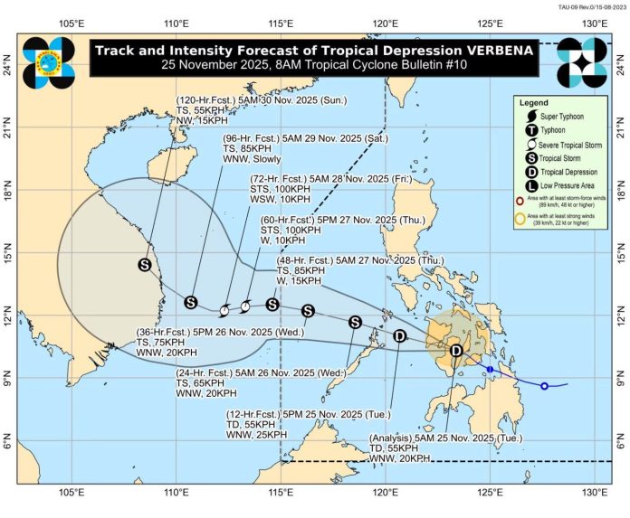
Tropical Depression Verbena made its fourth landfall early Tuesday in Vallehermoso, Negros Oriental, and is now crossing Canlaon City as it sweeps across the Visayas with strong winds and widespread rain.
As of 7 a.m., Verbena carried maximum winds of 55 kph and gusts of up to 90 kph, moving west-northwest at 20 kph. The system is expected to continue tracking across Western Visayas and northern Palawan through Tuesday night.
Landfall timeline:
* 1:30 p.m. (Nov 24) – Bayabas, Surigao del Sur
* 11:10 p.m. (Nov 24) – Jagna, Bohol
* 2:40 a.m. (Nov 25) – Talisay City, Cebu
* 5:50 a.m. (Nov 25) – Vallehermoso, Negros Oriental
PAGASA has kept Signal No. 1 raised over 29 provinces, covering much of the Visayas and portions of Southern Luzon and Mindanao. The agency also warned that Verbena may intensify into a tropical storm before exiting PAR early Thursday.
Rainfall will be severe and widespread, with the combined effects of Verbena and the shear line expected to lash the country through Wednesday.
Areas expecting intense rains today: Central Visayas, Negros provinces, Western Visayas, MIMAROPA, CALABARZON
Areas expecting intense rains Wednesday: Northern Luzon, MIMAROPA
Authorities warn of serious flooding and landslides, particularly in low-lying and mountainous communities. Residents are urged to monitor local advisories, follow evacuation orders, and take necessary precautions to protect life and property.
Image from DOST-PAGASA FB

